In a groundbreaking discovery, researchers led by Luke Auld-Thomas, a PhD student in anthropology from Northern Arizona University and doctoral student at Tulane University, have unveiled a lost Maya city complete with prominent pyramids concealed beneath the dense jungles of southeast Mexico.
This significant find not only expands our knowledge of the Maya civilization but also reshapes our perspective on their urban planning and societal organization.
Employing LiDAR technology, which stands for Light Detection and Ranging, the research team conducted an extensive survey of a 50-square-mile land area in east-central Campeche.
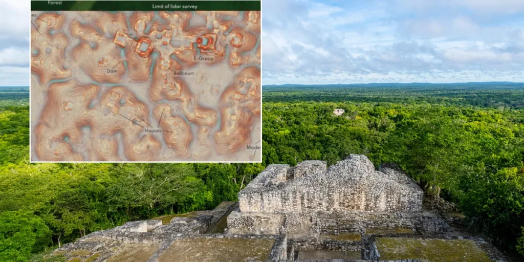
This region, previously overlooked by archaeological studies, yielded a trove of over 6,500 pre-Hispanic structures, including an uncharted city adorned with monumental stone pyramids situated near the area’s central highway.
LiDAR technology uses laser pulses to penetrate the forest canopy and detect what lies beneath. This method allowed researchers to create highly precise 3D models of the terrain, revealing hidden features of the landscape.
The technique proved instrumental in uncovering the high density and variability of Maya settlements previously concealed by the verdant jungles of the central Maya Lowlands—a region encompassing parts of Mexico, Guatemala, and Belize.
Among the most notable discoveries is the Valeriana site, a city comprising multiple plazas, grand pyramids, a ball court, and an engineered reserveoir accomplished by damming a dry creek bed—demonstrating the advanced landscape engineering skills the Maya employed to harness seasonal rainwater.
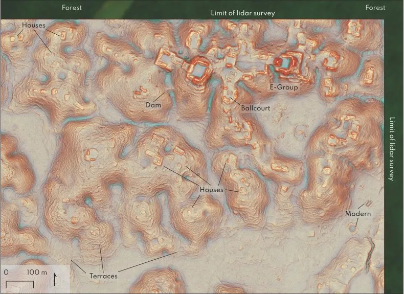
These features illustrate the Maya’s capability to convert natural surroundings into a highly organized urban fabric, supporting large populations and intricate communities.
This study, published in the journal Antiquity, sheds new light on the Classic Period of the Maya civilization, which thrived between A.D. 250–900.
Led by Tulane’s Middle American Research Institute (MARI) under the guidance of Professor Marcello A. Canuto, the research highlights the institute’s innovative use of GIS and remote sensing data in archaeological advancements.
The implications of this discovery extend beyond just revealing hidden cities; they challenge previous assumptions about the extent and interconnected nature of Maya society.
The evidence suggests a more intricate and populous ancient Maya world, which contrasts with earlier perceptions of a predominantly rural landscape.
This revelation highlights the transformative power of LiDAR technology in archaeology.
It not only uncovers forgotten civilizations but challenges our understanding, prompting scholars to reconsider the scale and complexity of ancient societies.
As researchers continue to penetrate the unexplored areas of the Maya Lowlands, further groundbreaking findings are all but inevitable.